Nebraska Railroads Converted to Recreational Trails
by Glenn Williams
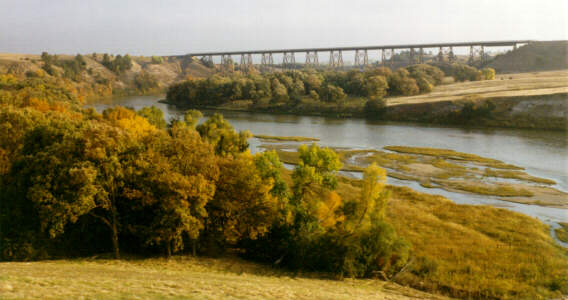
Photo of the Cowboy Trail bridge over the Niobrara
River near Valentine from web site for Yucca Dune Bicycle Shop, Valentine,
Nebraska.
Photo of the Cowboy Trail bridge over the Niobrara
River near Valentine from web site for Yucca Dune Bicycle Shop, Valentine,
Nebraska.
There are two primary types of trails in Nebraska: recreational trails and historical trails. Historical trails are those known as the Oregon Trail, Mormon Trail, and Pony Express Trail. Recreational trails are modern day paved, gravel, or wood chip trails within towns and cities, between cities, from cities, or long distance rural routes for modern hikers and bicyclists. These trails are for exercise, scenic views, and recreational enjoyment.
There are two types of recreational trails in Nebraska: former railroad corridors and those that are along other types of corridors. In the decade of the 1990's, recreational trail development in Nebraska has evolved from limited to active. There are now many kinds of recreational trails, existing, proposed, or under development in the state: stream levee trails, off-road roadside trails, scenic trails, and rails-to-trails. Some of these trails are more than one kind of trail, depending upon their location. Our focus will be primarily on the former railroad lines converted to recreational trails. These are rails-to-trails or rail-with-trail developments.
The advantage to a former railroad grade is that they are all gentle grades. There are no steep slopes to navigate. This is ideal for the average bicycle rider or hiker.
There are several railroad-to-trails conversions ongoing, completed, or proposed in Nebraska. They are under the control of various jurisdictions, from the state to local level and public or private groups. These trails are the MoPac and MoPac East, Oak Creek, Steamboat Trace, Keystone, Rock Island, David Murdoch, Fort Kearny, White River, and the Cowboy trails.
The trails range from short segments to the nation's longest. Most of these trails are located close to the state's population centers.
The Nebraska Rails-To-Trails story began in 1968. The state Game and Parks Commission purchased in southeast Nebraska what became known as the Iron Horse Trail between Beatrice and Dubois.
Originally, the plan was to have both wildlife habitat and a hiking trail. Then, local landowners disputed the railroad's sale to the commission of the entire tract. A dispute centered on what local landowners saw to be reversionary clauses that entitled them to the land. Nebraska Game and Parks Commission decided to hold two auctions. Thirty-three scattered parcels remain, owned by the Game and Parks Commission. These remaining parcels then became a wildlife habitat.
A possible trail corridor was lost about nine years ago. The proposed Trail of Two Cities between Lincoln and Omaha was to be a fifty-mile trail along an abandoned section of Rock Island railroad land. A group of area landowners beat a trail group to the bank within the same 24-hour period.
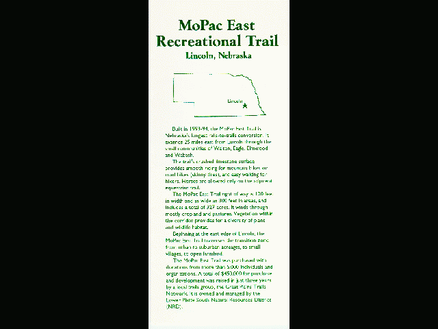
The recent growth of the state trails system started with success in a local trail group purchasing what became known as the MoPac East Recreational Trail. In 1984, extensive flood damage along the Missouri Pacific railroad lead to the Missouri Pacific railroad officially abandoning the rail line by 1990.
The Great Plains Trails Network (GPTN) trails organization in Lancaster County, a citizen-based trail advocacy group, formed soon after that. In less than a year, the GPTN raised $275,000 in a fund-raising campaign to meet the asking price for the 25-mile line.
In early 1991, the non-profit Nebraska Trails Foundation purchased the rail line. The Nebraska Trails Foundation serves as the depository for local trails groups. Property held by the foundation was given to the Lower Platte South Natural Resources District for development into a trail and wildlife habitat.
While most of these trails are on abandoned railroad right-of-ways, some are parallel to or near active railroads or spur lines. In Omaha the Keystone Trail, while located mostly on the Little Papio Creek levee, has a section of the trail that uses the abandoned Chicago and Northwestern railroad right-of-way.
Several state trails are on or near an active or abandoned railroad line. An example is the Field Club Trail in Omaha, maintained by Douglas county along an abandoned railroad right-of-way.
The Steamboat Trace Trail (Figure 1), along the former Burlington Northern Railroad in southeast Nebraska, is under construction between Brownville and Peru. Future Steamboat Trail extensions will reach the Nebraska City area. Eventually the trail may connect to the Omaha area trails.
The Oak Creek Trail (Figure 2) opened in the fall of 1996 between Valparaiso and Brainard, along the former Union Pacific Railroad. The railroad right-of-way was abandoned by the Union Pacific in October 1993. This twelve-mile trail segment goes from the North Oak Creek valley to a ridge line east of Loma. The trail continues along the ridge line to one-mile south of Brainard. The trail ends there and the active UP rail line begins.
The city of Lincoln is the leader of the recreational trail movement in Nebraska. For more than twenty years, a National Scenic hiking trail has been in existence along Salt Creek in Wilderness Park, maintained by the city Parks & Recreation department, but owned by Lancaster County. This is not a rail-to-trail conversion, but it is near some existing railroad lines. The city of Lincoln maintains the leadership position in trails. Lincoln was named recently by the American Hiking Society as one of the top ten trail towns in the USA.
Lincoln urban trails (Figure 3) include the MoPac, Rock Island, and David Murdoch trails. The MoPac Trail is along the former Missouri Pacific Railroad through the center of the city, mostly north of 'O' Street. The trail has two bridges, over North 48th Street and over East 'O' Street. Otherwise, the trail is at street level throughout most of its four miles.
The Rock Island Trail is along the former railroad line of the same name. It is four and a half miles in length. It merges with the Billy Wolfe Trail, along Antelope Creek, in Antelope Park. Heading northward in Antelope Park, the trail separates from that trail near South 21st Street. From there, the trail continues along the former rail line to 'O' Street. From there, the trail is on the south side of 'O' Street to North 19th Street. It follows North 19th Street to near Vine Street, where it follows the former rail line to just north of Vine Street.
Heading southward from Antelope Park, the Rock Island Trail follows the path of the former rail line to Old Cheney Road. New bridges, to replace the previously removed rail bridges, are at Nebraska Highway 2 and at South 27th Street, near the intersection of both streets. With a few exceptions, the trail is at or near street level. A short paper wrote by a UN-L geology professor discusses the geology along this section of the Rock Island trail.
The city owned David Murdoch Trail was under construction during the fall of 1996. While not officially open, it is complete from North 48th and Fremont Streets to Mahoney city park east of North 70th Streets. Plans are to rebuild the bridge over North 84th Street and complete the trail to its end at North 112th Street, near Havelock Avenue. The David Murdoch trail is along the former Rock Island Railroad in the southern part of Havelock, a Lincoln suburb.
An impressive rails-to-trails conversion is under construction in Northern Nebraska, along the former Chicago and Northwestern Railroad. It will be the nation's longest trail at 320 miles when completed. The trail is called the Cowboy Trail (Figure 4). It follows the former railroad line from the west side of Norfolk to Merriman. From Merriman to Chadron, a trail will be by the railroad. The railroad is the Nebkota short line, which runs trains on the former Chicago Northwestern rail line.
The trail is now open in sections near towns along the trail, such as Valentine and O'Neill. Near towns along the trail, there will be asphalt or concrete, done by local trail groups. Between towns, the trail will be crushed limestone or rock. Exterior restoration of the abandoned O'Neill depot along the Cowboy Trail is complete. Bed and breakfasts are opening along the trail. The trail is in several current national publications. Nebraska Game and Parks Commission, will maintain the trail, and prominently features the Cowboy Trail on its Internet World-Wide Web site, with a map, pictures, and background.
The National Rails-To-Trails Conservancy (RTC) has a prominent role in the creation of the Cowboy Trail in Nebraska. It donated the railroad right-of-way in a three-way agreement with the Game and Parks Commission, the NEBkota Shortline, and the RTC on December 5, 1994. Work on the trail has continued to the present, delayed only by the weather.
The two-hundred-fifty miles from Norfolk to Merriman will open first. The 30-foot easement along the NEBkota Shortline from Merriman to Chadron will be completed last. This will be a rail with a trail. Completion of the last stage will be about five years from now.
Elevation of the Cowboy Trail from Norfolk to Chadron increases from 1500 feet to 3500 feet above mean sea level. The trail goes from the Elkhorn River valley to the Sandhills and Pine Ridge areas. Several tourist attractions are near the Cowboy Trail. They include the Neligh Mills and Ashfall State Historical Parks, the Northeast Nebraska Zoo at Royal, Smith Falls State Park, and the Bowring Ranch State Historical Park. The counties the trail goes through are Dawes, Sheridan, Cherry, Brown, Rock, Holt, Antelope, and Madison.
There is another developed trail located along the same former Chicago Northwestern railroad. This is located west of Chadron, from Crawford through Fort Robinson State Park to Crandell, Wyoming, 2 miles inside Wyoming. This trail is the White River Trail.
The driving force behind this trail is Rick Kaan, a Harrison area rancher. This is unusual for a rancher to take an interest in trail development. Many area ranchers do not share his enthusiasm for trails.
In Howard County, the town of Dannebrog developed a one-mile paved trail along the former Union Pacific railroad line through town. Several trail segments around Dannebrog are from that initial trail.
The most recent effort underway in rails-to-trails development in Nebraska is to connect the existing trails with other trails or extensions to trails. Two of the efforts are only proposals. Fund-raising efforts are underway.
Proposals are to complete the MoPac East Trail from Elmwood to Wabash and build a 7 mile off-road trail north to the Rock Island rail bridge near South Bend. This bridge will eventually connect Lincoln and Omaha, although not in the same way as the Trail of Two Cities would have. A fund-raising effort is underway to purchase the former Rock Island rail bridge and the approaches to the bridge.
The MoPac East has not been completed east of Elmwood because a proposed dam site could change the trail alignment in that area. The connector trail from Wabash to the Rock Island bridge is not part of any rail corridor, but rather a proposed easement along county roads.
The MoPac East, MoPac, and Oak Creek trails are part of the American Discovery Trail (ADT). This is a plan to connect trails across America in a transcontinental trail system. Several trails have been designated as ADT trails in the states through which the trail would pass.
In Nebraska, the northern branch of the American Discovery Trail would pass through Omaha and Lincoln on its way to the Platte River valley. The ADT trail would wind mostly along the Platte valley in Nebraska. The southern branch of the ADT trail winds through Kansas.
Omaha is not as far along as Lincoln in trails development. While Lincoln has seventy-one miles of trails, Omaha hoped to have eighty miles of trails by the end of the decade. This goal seems far off, with trail mileage built mostly along only a few newly widened roads or creek levees in west Omaha.
The Field Club Trail is a rails-to-trails conversion along a former railroad line, owned by Douglas County. The Keystone Trail is partially rails-to-trails conversion. It is primarily along a creek levee. A proposed Keystone East trail would be the other rails-to-trails project in Omaha. The other trails are mostly along creek levees and newly widened streets and highways in west Omaha.
Lincoln, by contrast, has three rails-to-trails conversions completed or nearly done. The Missouri Pacific Trail in Lincoln will in the future extend west from 30th Street to 19th Street, to join the Rock Island Trail. Several miles of trails exist in the city parks system, along creek levees, and along widened streets throughout the city. A new railroad alignment parallel to the proposed south bypass highway could replace the Burlington Railroad line located just south of Nebraska Highway 2. This would create another rails-to-trails conversion in Lincoln.
Federal Intermodal Surface Transportation Efficiency Act dollars, known as ISTEA enhancement dollars, have spurred trail development throughout the state. In the Hastings area, a railroad bypass around the center of the town has created new rails-to-trails conversion opportunities. Grand Island's grade separation of the existing rails through town creates another trail possibility in its vicinity.
The rails-to-trails movement has increased in popularity in Nebraska's urbanized areas. However, any conversions still meet fierce opposition from rural landowners. They hope to have land returned to them, but federal law passed in both 1968 and revised in 1983 allow for rail banking. Future trail development is possible along any abandoned rail corridor, if there is an organized group that can make it happen.
Rail banking means that the abandoned railroad corridors are reserved for possible future transportation uses. This allows the creation of trails along abandoned rail lines, with the possibility that these areas could revert to rail use if they again become needed. This is the intention of rail banking.
The Natural Resource Districts (NRDs) are the logical entities to develop rail trails, because they are public multiple county corporations. Potential rails-to-trails corridors extend across multiple counties. If it were not for the Great Plains Trails Network and the Lower Platte South Natural Resources District, the Oak Creek Trail would never have happened. Intense local opposition would have prevented the trail from being built. Railroads prefer to sell their land to one entity or individual, rather than deal with hundreds of individuals. As a result, the NRDs often have first chance at the former railroad land when railroads sell their corridors.
Nebraska is not alone in having failures and successes in rails-to-trails conversions. Neighboring states and states across the country have faced both setbacks and success in their same local areas.
The future for recreational development in Nebraska and throughout the nation is in these ready made linear parks. As the nation becomes more urbanized, these will be indispensable resources waiting for public use. The economic benefit from these trails far exceeds the costs to rehabilitate and maintain these corridors. The best situation is to maintain a trail easement alongside an active rail system where possible.
Rail trails preserve corridors for future transportation or communication networks, which may include reviving the railroads that existed along them, if necessary. This is the intention of the nation's rail banking laws.
Nebraska has a long history of trails from migration to today's recreational trails. Nebraska recreational trail history is similar to other states, but with limited success until recent years. The future trend of trails development is accelerating in the state. This is due to the increasing organization of local trails groups.
Details of the sources of this paper are at a web site I created at https://nebraskatrails.tripod.com/ on the Internet World-Wide Web. On the web site are links to many information sources, scanned images of the brochures and maps, and other relevant information.
It is appropriate that Nebraska is becoming
a part of the recreational trail movement. Nebraska has always been a crossroads
for trails, from migration to transportation. Recreation is just one more
addition to that tradition.
Lincoln Parks & Recreation Department, brochures.
Papio - Missouri Natural Resources District; Omaha, Nebraska; map and phone interview.
E-mail interview with Ron Schlautman, State Bicycle/Pedestrian Coordinator, Nebraska Department of Roads.
E-mail interview with John Hitt, State Trails Coordinator, Nebraska Game & Parks Commission.
E-mail interview with Rich Rodenburg, local bicycle store owner.
Interview with Ross Greathouse, Nebraska Trails Foundation, March 28, 1997.
Interview with Pat Foote, Nebraska Game & Parks Commission, March 28, 1997.
Forsberg, Mike; "Rails-To-Trails Recreation
Trail Development in Nebraska"; NEBRASKAland Magazine, June 1994; reprinted
on the Nebraska Game & Parks Commission web site, at:
http://adm-server.ngpc.state.ne.us/infoeduc/rails.html
